[ China Instrument Network Instrument Development ] With the end of the new round of Earth observation cycle on February 20, the Tiangong 2D 3D imaging altimeter has been in operation for 888 days. To date, the Tiangong-2 altimeter has obtained a large number of observations of key sea areas and typical land areas. In oceanographic observations, a large number of typical ocean phenomena such as sea surface rain, heavy rainfall, internal waves, ocean fronts, swells, oil spills, eddies, and shallow sea topographical modulation are observed while conducting sea level height measurements. It will play a unique role in marine environment and marine scientific research. In terrestrial observation, the Tiangong 2 three-dimensional imaging altimeter successfully obtained the observation data of the typical surface of the Qinghai-Tibet Plateau lake and a large number of inland lakes, river water bodies, typical deserts, and Amazon rainforests. Preliminary studies have shown that its ability to monitor changes in water level in larger lakes is stronger than in radar in-orbit. Due to its high sensitivity to water bodies, the Tiangong-2 altimeter demonstrates its unique ability to observe coastal zones.
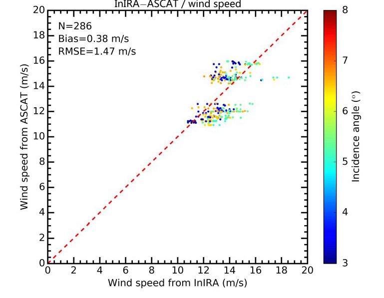
The accuracy of the Tiangong-2 altimeter and the ESA ASCAT wind speed inversion. The number in the color chart represents the angle of incidence
Recently, researchers from the Second Institute of Oceanography of the State Oceanic Administration, the National Satellite Ocean Application Center, and the National Space Science Center of the Chinese Academy of Sciences have made progress in the study of the sea surface wind speed inversion method of the Tiangong-2 altimeter, achieving high-precision inversion of sea surface wind speed. The research results were recently published in the IEEE FORUM OF SELECTED TOPICS IN APPLIED EARTH OBSERVATIONS AND REMOTE SENSING.
The spaceborne radar altimeter is a microwave remote sensor capable of accurately measuring sea level height with centimeter-level accuracy. It is one of the main remote sensors for marine dynamic environment observation. It is in marine science, marine environment observation and prediction, and global climate change research. It plays an irreplaceable role.
At 22:04 on September 15, 2016, the Tiangong No. 2 three-dimensional imaging microwave altimeter developed by the Key Laboratory of Microwave Remote Sensing Technology of the Space Center of the Chinese Academy of Sciences was launched at the Jiuquan Satellite Launch Base with the Tiangong No. 2 Space Laboratory. A breakthrough in the traditional spaceborne altimeter can only be used to observe the one-dimensional line of the sub-satellite point along the flight direction, and the width is only a few kilometers. The width of one side is up to tens of kilometers, and the relative measurement accuracy of sea level is up to centimeter. Absolute measurement Wide-width radar altimeter with a precision of decimeter (if the orbital height is more than 800 km, the observation width of more than 100 km on one side can be achieved). The Tiangong No. 2 altimeter can observe the three-dimensional shape of the sea surface and the ocean internal wave while achieving wide-width sea surface altimetry. It can also measure the sea surface wind speed and the effective wave and wave direction of the sea surface. The Tiangong-2 altimeter performs radar interference imaging observations of the Earth's oceans and land from space in an unprecedented 1-8 degree view. The observations obtained from this unique perspective present many unique phenomena, such as the presentation of surface and surface water bodies. Strong scattering is conducive to the observation of the Earth's water body, and the interference observation data of the desert shows good coherence.
The Tiangong-2 altimeter is the third international satellite-borne dual-antenna interference radar after the US NASA Endeavour Space Interferometric SAR (SRTM) test (2000) and the ESA ice-detecting satellite Cryosat-2 (2010) SIRAL. It is also the radar with the highest frequency of electromagnetic waves for imaging observations of the Earth.
Since the first launch of the Tiangong No. 2 altimeter on September 22, 2016, the equipment has been in good working condition and stable in performance. It has experienced the in-orbit test phase and the extended test phase. The on-orbit test results show that all engineering indicators and instrument performance indicators meet or exceed the mission requirements, and the observed amplitude exceeds 35 km. Under the condition of not equipped with a microwave radiometer for delay correction of wet atmospheric path, the atmospheric numerical model is used. The path test is estimated to make the sea level relative measurement accuracy reach 8.2 cm. Under the condition that the orbital accuracy is in the order of decimeter, the absolute accuracy is 21 cm, and the sea surface wind speed measurement accuracy is about 1.65 m/s. Better than 15 degrees.
The Tiangong No. 2 altimeter has achieved many technological breakthroughs and innovations:
In terms of overall technology, the first test in the world has verified the working mechanism of small-angle and short-baseline interferometry and new height-tracking technology to achieve centimeter-level measurement accuracy of wide-span sea level, and obtained the first three-dimensional in the world. Sea surface morphology observation results; in the design, simulation, development technology and high-precision signal processing technology of high-coherence radar system, the radar system's interference phase measurement accuracy reaches 0.02 degrees. The developed height tracker and automatic gain control algorithm realize automatic switching and adaptive tracking and control of global sea and land observations.
In terms of single technology, the world's first space-borne application of Ku-band over 100W high-power pulsed solid-state power amplifier; with Ku-band high-gain waveguide slot array antenna technology, integrated design, processing and welding of the largest single size in the country Signal processing methods and algorithms such as high-preservation imaging algorithms, high-precision positioning algorithms, and high-precision interference baseline correction methods are promoted.
(Original title: Tiangong 2rd 3D Imaging Microwave Altimeter has achieved a series of results)
Stone CNC Router is a high-tech automatic computer controlled engraving equipment capable of carving and calligraphy on natural stone, glass and ceramics. The stone Engraving Machine can engrave calligraphy and painting on stone, ceramics and ceramic tiles, which can meet the requirements of personalized home decoration and tooling art design. It can be used as an advanced engraving and processing equipment for decoration company, handicraft industry, stone industry, inscription industry and ceramic company.
Stone Cnc Router,Stone Cnc Machine,Cnc Stone Engraving,Cnc Stone Carving Machine
JINAN YIHAI CNC ROUTER MACHINERY CO.,LTD , https://www.yhcncrouter.com